ATRA News

    This is a round up of the latest news related Personal Rapid Tramsport and Advanced Transport. If you would like to submit a news item please email news@atra.org

    Suburban Office Parks: An Important Application for Last-Mile Automated Transit Networks

    March 3rd, 2016

    robert

    By Robert Johnson


    In recent years, a major change has taken place in what is considered a desirable location for office space, especially in large metropolitan areas.  Much more emphasis is placed on providing employees with easy access to transit and amenities such as restaurants and shops.  Unfortunately, over the last several decades an enormous amount of office space has been built that does not meet these new requirements.  In many cases, a small Automated Transit Network (ATN) can help an older office park provide the accessibility that is now considered necessary.


    Although an ATN can provide circulation within an office park, the applications considered here are primarily to connect the park with a high-volume transit station, typically on a heavy rail line.


    The wide roadways and expansive parking lots typically found in older office parks can provide the space for easy installation of ATN guideways and stations, either elevated or possibly at grade.  This is in contrast to CBD applications where space is at a premium and the visual intrusion of elevated guideways always a concern.


    The potential benefits of even a small ATN can be seen by looking at a possible application in suburban Washington, DC.  Because of government cutbacks over the past several years, demand for office space has declined, and this has affected even wealthy Montgomery County, Maryland, which is immediately northwest of DC.  As of Q2 2015, at least nine office buildings over 100,000 square feet in size stood empty, and many more were underutilized.  However not all office space in Montgomery County was affected equally.  The vacancy rate for traditional auto-centric office parks was 19 percent, while the rate for space in mixed-use business districts was 9 percent, indicating the advantage of being near other activities.RJBldg_Mar16


    One example of the benefits of being close to a transit station and other amenities can be seen in inner Montgomery County in the area around the White Flint station on the Washington Metro’s Red Line.  In the immediate vicinity of the station there has been extensive recent development, including some office space, and much more is currently underway. However, 0.8 miles to the west is a cluster of three large office buildings that are completely empty.  Two of these are shown in the photo.  Not only are they beyond walking distance from the Metro station, they are at least half a mile from the numerous restaurants and shops near the station that employees might want to patronize at lunchtime and before and after work.


    The access situation could be completely changed by a small ATN system.  The simplest system would be a 0.8 mile two-way line running from the station to the three buildings.  Without going into details, all of the streets along the route are divided arterials, and an elevated ATN system could be built along the medians.  In addition to a station at each end, there could be one or two along the way, providing additional benefits.  The end-to-end travel time would be under three minutes assuming a peak speed of 25 mph.  This system would be comparable in size to the one at Heathrow airport, London, so there should be no question of technical feasibility.


    According to public records, the two smaller of the three empty buildings last sold for a total of $73 million.  For far less than this amount, a small ATN system could allow these buildings and others nearby to meet current demands for access to transit and amenities. Robert-Johnson-Img_Mar16

    15th International Conference on Automated People Movers and Automated Transit Systems

    February 29th, 2016


    ATRA-The Transportation and Development Institute (T&DI) of the American Society of Civil Engineers (ASCE) is holding the 15th International Conference on Automated People Movers and Automated Transit Systems in Toronto, Ontario, Canada on April 17-20, 2016. Below is information about the conference.


    Automated People Movers and Transit Systems – Innovation in a Rapidly Urbanizing World


    More than half the world’s population lives in cities. In less than forty years it will be two-thirds as urbanization continues at a rapid pace. Airports are no longer in remote locations. They have become part of the urbanized landscape, with development occurring right up to the boundaries. World-wide, airline passengers are expected to rise 31% by 2017 with even more growth in future decades. For over half a century, APMs and ATS have played an important role in transportation in cities and at airports. The coming decades will offer even more opportunities and challenges as colleagues work together to improve the quality of life around the globe.

    U1

    Thus, it is appropriate to explore the role of innovative applications of APMs and ATS. How will these systems evolve? And how might PRT, autonomous road vehicles, and other new technologies contribute to the efficient movement of people? How might these systems work together synergistically with current and future physical infrastructure? The future is open to our collective imagination.

    U2

    The conference will be held in Toronto, the largest city in Canada and the country’s commercial capital, with a regional population of over six million. The Toronto Transit Commission operates the third largest mass transit system in North America with a wide range of modes including the Scarborough APM dating to 1985. Daily ridership is approaching three million trips. Toronto also is the location of Highway 401, the most highly traveled road in North America. Toronto Pearson International Airport is the largest and busiest in Canada. The Terminal Link Train APM opened in 2006. The Union Pearson Express (UP Express) opened in June 2015 and links Union Station and Pearson Airport. Toronto will be an exciting place for transportation professionals in 2016!

    In addition, the conference hotel is the historic and elegant Fairmont Royal York. Opened in 1929, this upscale hotel retains original features such as hand-painted ceilings and travertine pillars and is a 13-minute walk from the CN Tower and 1.3 km from the Harbourfront Centre. There are 4 restaurants, a cafe and a bar, as well as a spa with a 24/7 gym, an indoor pool and a whirlpool, plus a business center.


    During the conference, we will examine the current state of APMs and ATS, and explore what the future might hold. Share your opinion and hear what planners, inventors, designers, suppliers, builders, government officials, owners, and operators of automated transit of all forms have to say about these technologies. Network with your fellow attendees at meals and breaks, and talk to exhibitors about what equipment and services they have to offer. Take advantage of the ASCE APM conference’s international collegial community to share experiences, reveal innovations, look to the future, and discuss lessons learned and the latest developments in automated transit of all forms.


    Attending the technical program will make you eligible for professional development hours (PDHs) that can be used to show your commitment to maintaining your competency to licensing boards. And you can have fun doing it on a technical tour of the Terminal Link Train and the ground breaking accelerating High Speed Express Walkway at the Toronto Pearson International Airport.


    We welcome you from around the world for APM-ATS 2016 in Toronto!


    Steve Perliss, P.E., M.ASCE

    Bill Sproule, Ph.D., P.E., F.ASCE

    Michael R. Riseborough RPA,FMA,FMP,CFM,AAE,Aff.M.ASCE

    Craig Elliott, A.M.ASCE


    Conference Co-Chairs

    Notice to Potential Proposers: Proposed Automated Transit Network

    January 25th, 2016

    Greenville-Spartanburg International Airport District, Greer, South Carolina, USA, hereby informs potential proposers that it intends to issue a Request for Proposals (RFP) to qualified automated transit network (ATN) suppliers to participate in an ATN project connecting the existing economy lot to the terminal at the Greenville-Spartanburg International Airport (GSP). The RFP will be issued in the March/April 2016 timeframe. Proposers will have approximately six weeks to respond. This notice is intended to provide prospective proposers with the opportunity to prepare to respond. More information may be obtained at http://www.gspairport.com/BusinessOpportunities under “other”. Questions will not be entertained at this time.

    Synergies Between Driverless Transit and Driverless Cars

    January 20th, 2016

    Andreasson-header

    Synergies Between Driverless Transit and Driverless Cars


    Ingmar Andreasson, LogistikCentrum ABandreasson


    Developments of driverless transit on guideways (Automated Transit Networks – ATN) and driverless cars (DLC) can benefit from each other in several ways.


    Car developments are enabled by massive investments, bringing new sensors, advanced image processing and economies of scale. Car industries, by virtue of their size, gain political support, which helps in negotiating new legislation. So far DLCs are still experimental, being tested on public roads by local permissions only. Until DLCs eventually become legal on roads they can be introduced on guideways or other dedicated rights-of-way.


    The ATN industry has 40 years of accident-free driverless operation, approved certifications, track records for safety and reliability over 99.5 %. ATNs use proven control systems, empty vehicle management, ride-sharing strategies and intersection controls, which can all be applied to DLCs. As an example, ATN controllers allocate passage times to individual oncoming vehicles so that they can pass through intersections safely at speed.


    Even when DLCs have been introduced, guideways or more road-space will be needed in places where roads are congested. Cars can go on guideways and ATNs can go off guideway (Dual-Mode). The distinction between DLCs and ATNs will be blurred. Similarly the distinction between private and public transport was blurred by the introduction of shared rides and shared-use cars, whether private or publicly owned.


    With mixed-use guideways and roads, regulations of DLCs and ATNs must be harmonized. Present ATN regulations ensure levels of safety ten times higher than those of present car traffic. New systems are required to be at least as safe as existing modes – for ATNs the comparison has been with the safety of rail transit.


    What safety levels will be required for DLCs – the same as manual cars (easy) or as safe as ATNs? The car industry has no incentive to take risks so they will probably design for safe headways between vehicles, whether or not this is mandated.


    Even with V2V communication, safe headways may lead to reduced capacity and hence the need for more roads or guideways. Ride-sharing will be necessary to compensate for longer headways between cars. Every ATN system already applies ride-sharing and have done so since day 1.


    It is time for legislators to catch up with technical developments and harmonize safety regulations for driverless vehicles on roads and/or guideways.


    andreasson 2


    Rendering: Robert Jacobsson

    Innovating Automated Transit Technology With Students

    January 6th, 2016

    students

    By Burford Furman

    Professor, Mechanical Engineering

    San José State University

    December, 2015


    Summary

    Students have played a vital role in the development of automated transit since the early 1950s and continue to do so. At San José State University, we have been driving innovation in solar-powered automated transit network (ATN) development with students since 2012 and continue to the present day through the Spartan Superway Project.

    For the complete article please go to : http://www.advancedtransit.org/wp-content/uploads/2016/01/ATRA-Pulse-Article-for-January-2016-Innovating-Automated-Transit-Technology-With-Students.pdf


    Advanced Transit Systems – Necessary Industry Steps for Further Deployments

    January 5th, 2016

    orange-countyBy Walter Kulyk, P.E.


    Proponents of Advanced Transit (AT) system deployments must take bolder and newer steps to help deploy more and better AT systems across the country.

    AT systems for purposes of this article are those systems that include automated transit and automated roadway transit vehicle systems. Automated transit includes automated metro systems on guideways (such as the planned new system in Honolulu, Hawaii). These are generally limited to regional line-haul systems. Automated transit also includes Automated People Mover systems (such as that deployed in numerous airports), Personal Rapid Transit (such as the Ultra system at Heathrow Airport), Advanced Group Rapid Transit (originally studied and tested by the Urban Mass Transportation Administration in the 1970s and operating in Morgantown, WV since 1975 and the Netherlands since 1990), and Automated Transit Networks (such as those being planned in Sweden and the U.S.).

    AT systems also involve fixed route line-haul systems on protected transit ways. These allow for transit vehicles (buses) to cross over other traffic lanes when this movement is protected by traffic signal preemption. The Orange Line Bus Rapid Transit (BRT) system in Los Angeles, CA is an example. AT also includes transit network system technology applications that operate in demand response mode (such as buses or paratransit vehicles that use intelligent transportation system technology). Autonomous and connected roadway vehicles in transit service also fit into the AT category. These vehicles generally carry multiple travel parties in the same vehicle, while operating in mixed traffic. No fully autonomous systems exist yet. And research and development work is underway by the Federal Transit Administration (FTA) to study and potentially test fully connected (through dedicated short range radio based, GPS, or radar technology) roadway transit vehicles through an entire regional route. The AT category also includes hybrid transit operations that involve automated operating systems enhancing all modes of transit. This would include the new systems being tested in Europe under the CityMobil program.

    The history involving the research, study, testing, and deployment of AT systems is varied and spotty. It is a relatively long history going back to significant work being done in the 1960s on the Automated Highway System (AHS) at The Ohio State University. The Urban Mass Transportation Administration (the predecessor to the FTA) conducted studies and research in the 1970s leading to the Downtown People Mover (DPM) Demonstration program. This resulted in several deployments of DPM type systems in this country. These deployments included systems in Morgantown, WV; Detroit, MI; Jacksonville, FL; and Miami, FL. Although these systems were not all fully funded exclusively through the DPM demonstration program, they drew on capital funding influenced by the results and notoriety of that effort. The Urban Mass Transportation Administration (UMTA) also undertook studies, research, and limited testing in the late 1970s and early 1980s on the Advanced Group Rapid Transit (AGRT) concept. The concept was innovative at the time, and involved advanced propulsion and increased passenger loads over the DPM or PRT concept. However, due to reduced Federal funding starting with the Reagan Administration, the AGRT concept never was fully tested or demonstrated. Starting with new Federal legislation in 1993, the Federal Highway administration initiated the Intelligent Transportation Systems (ITS) program, which is still ongoing today. The initial period of the ITS program included a significant focus on automated highway vehicle studies. This resulted in a limited amount of funding for studies and testing of buses over the last 15 years involving crash avoidance and automated lane keeping and precision docking. Current efforts under the ITS program through the Connected Vehicle Initiative have placed renewed and increased interest on studies and testing on automated systems for both light and heavy duty highway vehicles, and also for those involving transit vehicles.

    All the studies, testing, demonstrations and deployments of AT systems to date, mostly in this country but also abroad, have resulted in only a handful of deployed Personal Rapid Transit (PRT) systems around the world. There have been over a hundred or so Automated People Mover systems deployed, overwhelmingly at airports funded largely by local dollars. There has been very little significant full scale testing and demonstrations of AT systems in this country beyond those DPM type systems mentioned earlier. The result has been a lack of awareness of the benefits of AT systems on the part of key decision makers at all levels of local, state, and federal government and by transit authorities.

    The opportunities for deployment of AT systems are rich. They include activity and satellite centers of employment. They certainly include regional and metro line-haul network systems on fixed guideways; fixed route line-haul metro bus systems on protected transit ways and in regular traffic; and autonomous and connected buses and other mass transit vehicles in regular transit service. In addition to these types of deployments, there exists potentially significant opportunities involving demand response mode transit networks; first mile/last mile connections at fixed guideway rail stations; and intermodal connections at high speed rail stations.

    But these opportunities are not being fully exploited. Due to a variety of reasons and factors, large barriers to the deployment of AT systems exist. The most notable factor has been the significant institutional inertia for the development of traditional bus and fixed guideway rail systems since the UMTA Act of 1968 which set up the federal agency and processes for federal involvement in, and funding for, new and improved transit systems in this country. These systems are generally expensive and historically have not involved significant advanced technology, certainly not autonomous or fully automated. There has grown a transit industry bias and institutional lobby for such systems. Certain national industry organizations have predominant members whose interests lay in the planning, designing, and deploying of these expensive systems.

    Over time, heavy emphasis on regulations dealing with capital funding has not adequately addressed the factors which make AT systems desirable, but rather has placed emphasis on large cost heavy rail systems. In addition, starting in the 1970s and continuing until recently, there has been a heavy hype by PRT proponents for this type of system as competition, rather than a complement, to metropolitan guided rail systems. This has soured many in the transit industry over the PRT type of system. This bias against PRT has been led by local authorities, national organizations, and design and construction engineering firms. Additionally, the lack of new and recent studies, research, testing, and full scale demonstrations have all led to a very limited transit industry knowledge and understanding of AT systems, further exacerbating the small deployment of these systems. Finally, there is no well-developed and coordinated strategic plan for the national deployment of AT systems. All of these issues and factors have inhibited the deployment and growth of such systems.

    In order to overcome these barriors and take advantage of several institutional forces currently underway (which include emphasis on automated and connected vehicle technology research, development, and testing through the ITS Program at the Department of Transportation), the AT systems community must take on a number of important actions. First, national organizations (including ATRA and others), must develop and conduct a continuous and rigorous education outreach program geared to alerting community leaders and those at the state and federal level of the benefits of AT systems. This program must complement active interaction with the executive and legislative branches of government at the local, state, and federal levels. Continuous and strong interaction with the various national organizations devoted to influencing national policies on planning, developing, and deploying new transit capital assets is also very necessary. The identification of champions at the local level for new AT systems is also critical. It is these champions who can have a strong influence of where these systems will be incorporated. The AT systems industry must also help to influence the development of public policy and support for new AT systems. Such public policy and support will lead to the increased funding of studies and research in this area. And most importantly, it will lead to highly necessary, full scale testing and demonstrations of AT systems. This will help identify technological issues and barriers and result in a broader acceptance and ultimate deployment of more and better AT systems.

    These actions will not immediately enable grand scale AT system deployments. But they must be done in a coordinated and intense fashion. Only then will the transit industry fully accept what these systems can offer – an improvement to the safety, efficiency, and cost of new and existing transit systems in this country.

    KulykPIC_Jan2016Walter Kulyk, P.E.

    PRESS RELEASE FROM PODARIS

    December 7th, 2015

    podaris

    PRESS RELEASE: A British company, Podaris Ltd., has announced the first public release of their online transport-planning software, which includes support for Personal Rapid Transit systems. It is freely available at app.podaris.com.

    Podaris was founded by former transport planner Nathan Koren, who previously led PRT feasibility and engineering studies in the UK, India, and elsewhere. “I started Podaris because I was frustrated with how transport projects are planned,” says Koren. “They are developed in a very slow, cumbersome, and rigid way. Historically, there’s an important reason for this: transport projects involve so many experts and stakeholders — planners, engineers, technology vendors, architects, property developers, historic and environmental preservation groups, neighbors, regulators, insurers, and many more — that the only way to manage them all has been with lot of process and paperwork. Times have changed, and there are better ways to do collaboration now. But planning processes haven’t changed for decades.”

    PodarisExample1

    Koren thinks that this is a major problem. “The McKinsey Global Institute estimates that the world could save $200 billion dollars every year with better early-stage planning and design practices,” he says. “And they’re just talking about the status quo. If you’re trying to do totally conventional infrastructure, then all those gaps and frictions between disciplines and stakeholders lead to enormous delays and cost overruns. But if you’re trying to do something that is actually innovative — like a PRT system — then those gaps and frictions become fundamental barriers to innovation.”

    Podaris is attempting to solve the problem. Borrowing techniques from online collaboration platforms like Github or Google Docs, Podaris is meant to put all the collaborators on the same page. “It’s a totally different paradigm for planning infrastructure,” says Koren. “You’re not passing paper between desks or even files between computers. Instead, everybody is working on a single shared model which lives in the cloud and is always up-to-date.”PodarisExample2


    Koren believes that this will improve the collaboration process, saving time and money and improving the capacity for innovation. But he emphasizes that these are early days for the platform. “We’ve just launched our initial product, and still have a long way to go,” he says. “We don’t even have any documentation yet, although we’re always happy to tutor people as they learn the software. We still need to build capabilities for 3D engineering, demand-modelling, capacity-modelling, costing, and so forth. There’s also lot of additional functionality we can build now that the plans live in the cloud — integration with 3rd-party transport networks and demographic datasets, for example. And eventually we’ll provide a way for Podaris’ real-time collaboration capabilities to be extended to existing platforms like AutoCAD and ArcGIS”.PodarisExample3


    Podaris is not only borrowing technology from other online collaboration tools, it is borrowing business models as well. It will always be free for non-professional users. “We felt it was important that individual students and enthusiasts be able to have access to this at no cost,” says Koren. “Ultimately, by making Podaris cheap and easy to adopt, and by making it play well with other planning and engineering platforms, we’re hoping to make Podaris a universal synchronization layer for infrastructure planning. We think this will literally change the way cities are designed — ultimately making it possible to bring forward innovations like Automated Transit Networks”. See Website: http://www.podaris.com

    Proposals for Driverless connections between Stockholm and Lidingö Centre

    November 30th, 2015

    By Göran Tegnér, Transek Companystockholm


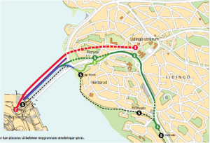
    The municipality of Lidingö is an island northeast of Stockholm inner city with 45,000 inhabitants. It is connected to Stockholm via a 6-lane 0.7 km long road bridge and an old tramway and bicycle bridge. The 101 year old Lidingö tramway line has just been re-opened after a two-year upgrading into a modern LRT line. The LRT line connects to the Stockholm metro on the other side of the bridge at Stockholm city border. However the LRT line does not pass the centre of Lidingö. A recent decision has been taken to develop the central part of Lidingö with new housing, more public service and also to double the size of the shopping area. The old tramway and bike bridge has to be replaced by some modern bridge, as repairing the old steel bridge would be too costly.


    1


    Two official solutions have been presented:

    • A new LRT & bike bridge combined with a re-routing of the LRT line via Lidingö centre
    • An extension of the metro line (on a new/alternative bridge from Ropsten in Stockholm to Lidingö Centre (estimated cost: 250 M€ or $ 275 M)2

    Both alternatives are costly and to get partly state funding for the investments, Lidingö will have to negotiate with the government to build up to 4,200 – 5,600 new apartments.

    Legend: Red line = proposed metro extension; Black dotted line= existing LRT line; green line: proposed re-routing of LRT line; Ropsten T (left on map) = Existing metro station in Stockholm; hpl Bodal S (lower right): a site for P+R and for a driverless shuttle bus (see below) Ropsten and Bodal impossible to read on map

    I would suggest three other transport solutions that ought to be analyzed as both better and more cost-efficient to LRT or metro extensions, namely:

    1. A podcar network that combines the LRT –line with both Lidingö Centre and the Ropsten metro station
    2. A driverless mini-bus shuttle between the Bodal LRT station (see map above) and Lidingö Centre
    3. A driverless Cable car between Ropsten metro station in Stockholm and Lidingö Centre


    A Podcar network3


    Instead of a 1 km metro extension to the Lidingö Centre estimated to $ 275 M one might get a 6 km Podcar network with eight stations, including seven stations in Lidingö costing about $ 50 M with :

    • One station at Bodal LRT stop and a P+R commuter parking;
    • One intermediate station;
    • Two loops around the Centre with 3 small podcar stations – located at the second floor inside new commercial buildings;
    • Two stations in Torsvik on the way toward Stockholm and a connection to the metro station in Ropsten.
    • 4


    The disadvantage of PRT is that it leads to more transfers, but, on the other hand, the podcar vehicle is waiting for you. Experience from the London Heathrow Ultra Global PRT shows that 90 % of the travelers have to wait less than 1 minute (less than 10 seconds average waiting time) for the ride.


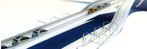
    The total number of transit trips between Stockholm and Lidingö is presently around 30,000 per day and 2,500 in the peak hour. Before the year 2030 ridership might increase up to 40,000 – 45,000 transit trips. A rough estimate of the Podcar ridership in Lidingö 2030 might be between 15,000 and 20,000 daily trips. This corresponds to approximately 2,100 – 2,800 trips during the busiest afternoon hour. A podcar network with 140 vehicles is estimated to cost about $ 50 M, or one fifth or the metro cost.                                            Figure 2. Beamways system in Linköping.


    Image: Hans Kylberg5


    At 20 % of the metro cost, one will get a much better transit system with much shorter waiting times and a system that covers a much larger area.


    A Driverless minibus shuttle

    A driverless shuttle bus that connects the Lidingö LRT line and the southern parts of Lidingö with the enlarged Lidingö Centre can meet all LRT line arrivals to the current stop and cause almost no waiting. The shuttle bus could go into a loop around the new Lidingö Centre.


    The CityMobil2 project

    Driverless bus shuttles have been in operation for more then ten years in the Netherlands, and this system is now being tested in La Rochelle, France, so the technology is relatively well proven. The buses run on ordinary roads in mixed traffic with full security. Now there is an EU project, CITYMOBIL2, with the aim of spreading knowledge of such innovative bus shuttles. I am convinced that this is worth studying more closely for Lidingö, but also for other municipalities in Stockholm County. I intend to contact the County Council, which is responsible for the county’s public transportation, in this matter. Facts about Park Shuttle in Rivium Business Park, Capelle Ann den Ijssel, the Netherlands:•       Battery-operated mini-buses with 20 seats•       2.5 min frequency in peak hours•       2,500 passengers per day•       Demand driven in off-peak hours•       1,800 meters distance•       5 stops•       6 buses

    The Park Shuttle system is operated at a cost similar to that of a bus line, but provides a much better service level (2.5 vs. 12 minutes). Personnel costs are substantially lower as only one operator is required to keep 6 vehicles running.With 24 departures per peak hour the capacity is 480 passengers per direction.

    A driverless bus shuttle could both serve the Lidingö LRT travelers, and also serve as a shuttle for motorists to get to and from Lidingö Centre from the P+R parking (about 2.5 km away) facility now being built. This parking could also serve as a “remote” parking and relieve some of the planned downtown parking lot, and also reduce the costs of the underground city parking lot, which then could be built smaller.

    6

    I believe this is a very interesting option that should be studied and analyzed into more detail. “My” Liberal party at Lidingö has accepted this idea, but not the conservative majority parties.


    A Driverless Cable Car between Stockholm and Lidingö

    Depending on the division of responsibility between the municipality of Lidingö (local road an building planning), the Stockholm County Council (public transport planning) and the National Government (major infrastructure and housing policy), one could label the various bridge connections as “bridge over troubled waters”…

    But why a bridge at all? “Urban Cable cars ready for take-off. Do you remember those funny cabins that would carry you to the top of the mountain during your last ski holidays? Well get ready to see them in cities too. The urban cable car is becoming established as an increasingly sustainable means of public transport.

    From New York to Caracas and Rio de Janeiro, there are more and more urban cable-car initiatives all over the world. Today, we have found over fifty of these structures in the largest cities”, as Sustainable-mobility.org formulates it.


    The Roosevelt Island Tramway, built in 1976 was upgraded in 2010. It is an aerial tramway in New York City that spans the East River and connects Roosevelt Island to the Upper East Side of Manhattan. The tram moves at about 17.9 mph (28.8 km/h) and travels 3,100 feet (940 m) in 3 minutes. Two cabins make the run at fifteen-minute intervals from 6:00 a.m. to 2:00 a.m. (3:30 a.m. on weekends) and continuously during rush hours.


    The Emirates Air Line. In the summer of 2012, London’s first urban cable car crossing the River Thames opened between the Royal Docks and the Greenwich peninsula. The London Mayor has secured a ten-year £ 36 M sponsorship deal for the new cable car with Emirates Airline. “Flying” over the Thames since 2012, it provides an unobstructed view over the city as it travels one kilometre between Greenwich Peninsula and the Royal Docks, just five minutes from the Olympic village by North Greenwich Tube station.


    7


    An urban cable car connection between the Ropsten Metro station and Lidingö Centre, a distance of about 2.5 km, and with one intermediate stop at Torsvik, could be an appropriate solution at a much lower cost than the proposed quite expensive metro solution. Today the peak hour demand is 2,300 passengers by bus and by the LRT line together across the water.


    A Tricable Gondola can carry up to 6,000 passengers in 35 passenger cabin at a speed of 24 -27 kph. A high forecast for the future demand would reach about 5,500 passengers per hour per direction. With departures every 14th second such a demand can be managed.
    Rough cost estimates based on a feasibility study made by the Stockholm Transit Authority (SL) (and applied to this project idea) results in a capital cost of about $ 25 – 30 M. This is on tenth of the costs for the metro extension! The annual operating costs are calculated to amount 5 % of the total capital cost, that is $ 1.5 M per annum.


    I believe this is a very interesting option that should be studied and analyzed into more detail.


    What are the benefits of driverless transit systems compared to heavy rail and LRT? 

    • Shorter travel times (substantially reduces travel an waiting times)
    • Serving a wider area with several stops compared to only one metro station
    • Higher seating capacity than the Lidingö LRT line
    • Low operating costs as podcars are driverless
    • Shorter construction period than for metro
    • Savings in the local bus network
    • Increased value of real estate with increased availability
    • Attracts motorists who could leave their car at home
    • Reduces car ownership and the need for parking space
    • A spectacular and innovative land-mark for Lidingö.
    • A futuristic sustainable transport, reducing the climate impact of car traffic


    Greetings to the Naysayers !

    October 30th, 2015


    ATRA-11

    Article by Alexander KyllmannATRA_Killman_Nov15


    Do you think Personal Rapid Transit (PRT) sounds cool but will never be implemented as an urban transit solution? Or that it’s an idea whose time has come and gone with the advent of driverless cars? You’re right. And wrong.


    Automated Transit Networks (ATN), whether PRT or GRT (Group Rapid Transit), are meant to be rapid transit solutions – as indicated by their names. By definition, rapid transit is different from other forms of mass transit by its operation on exclusive right-of-way, with no access for other vehicles or for pedestrians, in order to raise average speed well above the average speed of metropolitan mixed traffic. And this requires infrastructure, either new (additional) infrastructure or existing infrastructure but with a new dedicated use.


    atra-700
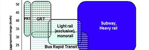
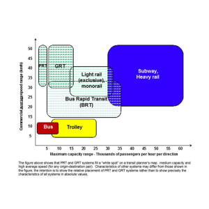
The boom in Bus Rapid Transit (BRT) systems worldwide over the past 15 years demonstrates that giving new use to existing infrastructure – e.g. dedicating existing traffic lanes to buses (typically high-capacity buses) – makes sense, wherever and whenever this can be done. In many cities, however, the number of avenues where BRT corridors can be implemented is very limited. Furthermore, while travel on BRT is certainly faster than on a conventional bus, intersections often place a relatively low limit on the average speed of surface-level BRT.


    To be effective, a city’s rapid transit network needs to reach well beyond the main avenues where it is easy to implement BRT. It also needs to offer its users total commuting times (waiting times + travel times) that are comparable to or better than travel by car. It needs to be safe, which includes a safe environment for its users (without having commuters packed like sardines into a train or bus, hoping their wallets or mobile phones will still be in their pockets when they exit). And it needs to be sustainable, both environmentally and economically.


    ATN systems, with smaller and lighter driverless vehicles, and leaner infrastructure, should deliver in all these respects. But, at what capacity level ? Dedicating infrastructure, whether new or existing, to a transit system must definitely be worth it, and this is true in any country. ATN systems have been and continue to be criticized for not being capable of carrying a significant traffic load that would warrant the investment. Most experts will agree that a GRT system can transport 10,000 or more passengers per hour per direction on the main line. Line capacity, however, is only part of the equation; it needs to be matched with station capacities to avoid bottlenecks. It has only been recently that the ATN industry has started to make significant progress in the area of station design and the corresponding guideway layout in and around stations. One thing is certain, however: a system with “personal” vehicles will never have the rush-hour capacity and will always be much more complicated and costly to manage at the stations than a system that systematically groups passengers.


    So, where do ATN systems fit on a transit planner’s map? Where medium-capacity, high-average-speed lines or networks are needed, in order to complement and improve a city’s existing transit network. Urbanization continues worldwide, and providing better urban mobility in the coming years will require multiple solutions, not just one. Driverless cars, or pods, will play an important role, especially when used as part of an Automated Transit Network with systematic ride sharing. Someday soon, the acronym PRT will no longer refer to “Personal Rapid Transit” but to “Pod Rapid Transit”. Regards to the naysayers!

    atra-700

    The figure to the right shows that PRT and GRT systems fill a “white spot” on a transit planner’s map: medium capacity and high average speed (for any origin-destination pair). Characteristics of other systems may differ from those shown in the figure; the intention is to show the relative placement of PRT and GRT systems rather than to show precisely the characteristics of all systems in absolute values.


    About the author: Alexander Kyllmann is co-founder and CEO of ModuTram Mexico, member of the ATRA Industry Group.


    WORKSHOP – Transit Vehicle Technology and Their Impact on Sustainable Transport TVT 2016

    October 27th, 2015

    Atra-Conf

    23- 24 April, 2016 – Rome, Italy

    In conjunction with the International Conference on Vehicle Technology and Intelligent Transport Systems – VEHITS 2016 


    Chaired by:    Professor Rongfang (Rachel) Liu


    The workshop will showcase various transit vehicle technologies and operations that have significant impact on the sustainable development of urban environment. The occasion will bring together researchers, practitioners, and decision makers from all over the world to explore the interaction between transportation, especially urban transit, and nature and built environment, energy consumption, and sociecty values.


    ORGANIZER:

    Telerik.Web.UI.WebResource.axd

    Dr. Liu is a transportation professor in the Department of Civil and Environmental Engineering, New Jersey Institute of Technology (NJIT). Her research interests include Intermodal and Multimodal Transportation Planning and Engineering, Operation Research and Network Simulations, and transportation safety performance analyses. Rachel was the Chair for TRB Committee AP040: Automated Transit system (ATS) for 2008-2014. Dr. Liu has authored a number of books, book chapters, referred journal papers. She also made more than a hundred presentations in the transportation, urban planning, and related fields. She has just completed a book titled: Automated Transit: Planning, Operation and Applications, which will be published by Wiley and Sons.


    TIME AND PLACE:

    April 23-24, 2016. Rome, Italy.


    SUBMIT PAPER/ABSTRACT:

    http://www.vehits.org/TVT.aspx.